The Jurassic limestone and Northampton Sand Formation that underpin much of the town create a deceptively complex near-surface geology. A thin layer of glacial till overlying ironstone can mask velocity contrasts that only a well-executed MASW survey will reveal. For engineers working on brownfield redevelopment near the Waterside Enterprise Zone or new residential blocks rising along the Bedford Road corridor, determining VS30 is not a box-ticking exercise; it is the difference between a safe ground type classification and an expensive redesign six months into construction. The seismic refraction method can provide complementary first-arrival data where bedrock depth is uncertain, while a dedicated seismic microzonation study becomes essential for larger masterplan sites that straddle multiple soil profiles.
VS30 is not a single number you extract from a table; it is the integrated shear wave velocity of the top 30 metres, and getting it wrong in Northampton's variable drift geology can shift your site class by a full letter.
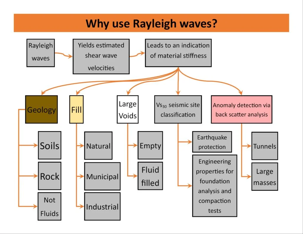
Process overview
For projects that also require bearing capacity verification, the MASW dataset pairs naturally with CPT testing to develop a continuous stiffness profile from the surface down to the weathered bedrock interface.
Local context
Northampton's Victorian and Edwardian expansion pushed terraced housing across the valley slopes without the benefit of modern seismic characterisation. Today, the same sites are being densified with three- and four-storey apartment blocks that carry heavier vertical loads and tighter lateral drift limits. The 2011 Market Harborough earthquake—a modest 3.8 magnitude event felt across the county—reminded local authorities that the East Midlands is not seismically inert. A site misclassified as ground type B when it should be type C or D under Eurocode 8 will attract a higher design spectrum and potentially unnecessary foundation costs. Conversely, underestimating the site period can lead to resonance effects in mid-rise structures. The British Geological Survey's own VS30 mapping for Northampton is based on topographic slope proxies, not direct measurement; site-specific MASW data overrides these regional estimates and carries far more weight with building control and warranty providers.
Reference standards
BS EN 1997-2:2007 – Eurocode 7: Ground investigation and testing, BS EN 1998-1:2004 – Eurocode 8: Design of structures for earthquake resistance, BS 5930:2015 – Code of practice for ground investigations, NEHRP (BSSC) 2020 Recommended Provisions for Seismic Regulations, ASTM D4428/D4428M – Standard Test Methods for Crosshole Seismic Testing (referenced for velocity calibration)
Additional services
VS30 Site Classification Survey
Full MASW acquisition and processing to determine the average shear wave velocity of the upper 30 metres. Delivers a Eurocode 8 ground type (A through E) and the site period Ts. Includes a comparison with any available neighbouring borehole or CPT data to strengthen the ground model.
2D Shear Wave Velocity Cross-Section
Multiple parallel or overlapping MASW arrays processed into a continuous 2D Vs section. Suitable for sites with lateral heterogeneity, cut-and-fill transitions, or buried channel features common along the Nene floodplain. Used by structural engineers to assess differential stiffness beneath mat foundations and pile groups.
Typical parameters
Top questions
How long does a MASW survey take on a typical Northampton site?
For a single array covering 46 to 69 metres, field work is completed in 90 minutes to two hours, assuming clear access and daylight. Processing and reporting add three to four working days. Larger 2D campaigns with multiple spreads may require a full day on site.
What is the cost range for VS30 testing in Northampton?
A standard single-array MASW survey with VS30 determination and an EC8 ground type letter falls between £1,310 and £2,120, depending on array length, site access constraints, and whether traffic management or line-of-sight clearing is needed.
Can MASW be performed on tarmac or concrete surfaces?
Yes. The geophones are planted with coupling plates on hard surfaces. We record a few extra shot stacks to compensate for the slightly reduced coupling compared to soil. The dispersion curve remains reliable; surface paving actually helps suppress air-wave noise.
How does MASW compare with a downhole seismic test?
MASW is non-invasive and averages velocity over a broader volume, which suits site-response studies. Downhole testing requires a cased borehole and gives a higher-resolution measurement at a single point. For Northampton sites where we already have CPT or borehole logs, the two methods complement each other well.
What ground type classifications are typical for Northampton?
Sites on the Northampton Sand Formation often return ground type B (Vs30 360–800 m/s). The alluvial corridor along the Nene tends toward type C (180–360 m/s), and isolated pockets of deeper soft clay can dip into type D. Our surveys frequently refine a preliminary desk-study classification by one or two sub-classes, which directly impacts the seismic design coefficient.