The terrain around Northampton tells two very different stories. Down in the Nene Valley, you get the soft alluvium, but up on the ridges towards Kingsthorpe and the old ironstone workings, the ground changes completely. You're dealing with the Marlstone Rock Bed and the underlying Upper Lias Clay — materials that have shaped the town's building history but also its geotechnical challenges. In our experience, a generic desktop study simply doesn't cut it here. The transition zones between the permeable ironstone and the clay create perched water tables that catch people out. A solid slope stability analysis has to start with a proper ground model that reflects this layered geology, which is why we always tie our limit equilibrium models back to high-quality test pits and borehole data to confirm the depth to bedrock and the actual groundwater conditions before any factor of safety is calculated.
On Northampton's ironstone escarpment, the difference between a stable slope and a creeping failure often comes down to a single clay bed less than 50 millimetres thick.
Process overview
Local context
Northampton sits at elevations ranging from about 55 metres in the valley floor to over 110 metres on the northern ridge, and with a population exceeding 245,000, the pressure to build on marginal sloping sites has never been greater. The town's expansion into former quarry areas means we're frequently assessing slopes that have already failed once, 150 years ago, and have since been landscaped. The residual strength along those old slip surfaces in the Lias Clay can be as low as 12 degrees. Add a wet winter like 2024, and you've got a recipe for reactivation. The risk isn't just to the slope itself — a shallow translational failure in a rear garden can undermine a house footing in hours. For commercial developments near the A45 or the new housing estates on the northern edge, the consequence class rises, and we move from a straightforward Factor of Safety check to a full reliability analysis, often recommending retaining walls or anchors as part of the stabilisation design where space is tight and earthworks aren't feasible.
Reference standards
BS EN 1997-1:2004 (Eurocode 7, Part 1 — General Rules), BS 6031:2009 (Code of practice for earthworks), BS 5930:2015+A1:2020 (Code of practice for ground investigations), CIRIA C580 (Embedded retaining walls — guidance for economic design)
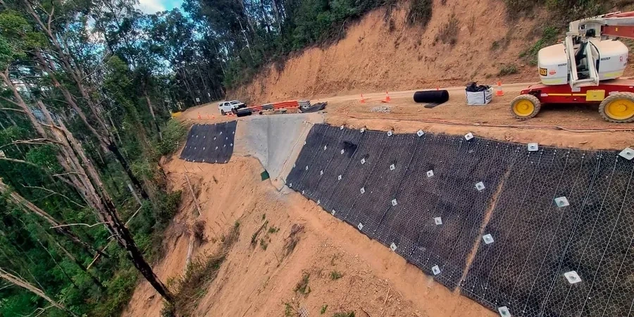
Additional services
Geotechnical Slope Assessment and Limit Equilibrium Modelling
A complete package starting with a walkover survey to map geological features, springs, and tension cracks, followed by a targeted ground investigation. We then build a 2D limit equilibrium model using the lab-derived strength parameters from the Northampton Sand and Lias Clay, running drained and undrained scenarios to deliver a design Factor of Safety compliant with BS EN 1997. The final report includes sensitivity analyses and practical stabilisation recommendations.
Stabilisation Design and Construction Validation
Once the failure mechanism is understood, we move into remediation design — this might involve regrading, drainage blankets to capture perched water, soil nailing, or toe berms. We prepare construction drawings and specifications, and our team can supervise the earthworks to validate that the as-built geometry and groundwater conditions match the design assumptions, closing the loop between analysis and safe construction.
Typical parameters
Top questions
What triggers a slope stability problem on Northampton's geology?
The main trigger is almost always water. The Northampton Sand is a natural aquifer, and when prolonged rain saturates the ironstone, pore water pressures build up at the contact with the underlying Lias Clay. This reduces the effective stress and the available shear strength along that interface. Other triggers we see include uncontrolled excavation at the toe of a slope — someone cutting into the bottom of a bank to level a garden, for example — and leaking drains that act as a constant water source into the slope.
What factor of safety do I need for my slope to get building regulations approval?
For permanent works under Eurocode 7 as applied in the UK, you're typically looking at a minimum Factor of Safety of 1.30. For temporary works during construction, 1.10 is generally acceptable. The actual required value can increase depending on the consequence class of the structure at risk. If a failure could affect a public highway or multiple properties, the building control officer or NHBC will expect a higher reliability index, and we factor that into the analysis from the start.
How much does a slope stability analysis cost in Northampton?
The fee for a slope stability analysis in Northampton typically falls between £1,120 and £3,430. The final cost depends on whether existing ground investigation data is available or if new boreholes and lab testing are needed to define the strength parameters and groundwater regime. A simple assessment for a single residential plot using existing data sits at the lower end, while a full investigation with lab testing and complex limit equilibrium modelling for a commercial development will be at the higher end.
Can I build on a slope that has already failed in the past?
Yes, but it requires a very careful approach. A slope that has previously failed in the Lias Clay will be at residual strength along the slip surface, not peak strength. You can't just assume standard published friction angles. We need to sample the shear zone, measure residual strength in a ring shear or reversal direct shear test, and then model the stability using those lower parameters. Often the solution involves unloading the head of the slope, adding a toe berm, or installing deep drainage to lower the water table permanently.
How long does a slope stability investigation and report take?
For a typical residential project in Northampton, you're looking at four to six weeks from instruction to final report. Week one is the walkover survey and planning any intrusive investigation. Weeks two and three cover the drilling, sampling, and lab testing. The modelling and report writing take another two weeks. If the slope is particularly sensitive or has complex historical mining features, it can extend to eight weeks, but we'll give you a clear programme before we start.