A recent warehouse extension near the M1 junction 15 stalled for three weeks because trial pits hit water at 2.8 metres and the contractor had no idea how deep the granular fill really went. The original borehole log said 'sand and gravel to 6 m', but resistivity lines run by our team showed a buried channel cutting through the Northampton Sand Formation—thickness varied from 1.9 m to over 7 m across just 40 metres. That kind of lateral change is exactly what Vertical Electrical Sounding picks up. We use it routinely across Northampton to map the interface between made ground, river terrace deposits, and the Lias Clay beneath. For projects where boreholes alone miss the bigger picture, we often combine resistivity with test pits to ground-truth the transitions and refine the geoelectric model before foundation design starts.
A resistivity line costs less than a second borehole and often reveals more about the ground than three boreholes spaced 15 metres apart.
Process overview
Local context
Much of Northampton sits on a thin cap of Northampton Sand over Lias Clay—a sequence where resistivity contrasts are strong but can be misinterpreted if the clay is silty rather than pure. The Lias Clay has typical resistivity below 25 Ωm, while the ironstone-rich Northampton Sand can exceed 200 Ωm when dry. The problem is that saturation collapses the contrast: waterlogged sand drops to 40–70 Ωm, sometimes overlapping with the clay response. We have seen sites where contractors assumed the clay was at 3 metres based on resistivity alone, only to find it was saturated sand that required a completely different excavation support strategy. A second pitfall is buried services—Northampton's older industrial estates near Brackmills have undocumented backfill with metallic debris that creates false low-resistivity anomalies. We always request service clearance plans before laying out electrodes, and we run a trial line across the site to flag cultural noise before committing to full coverage.
Reference standards
BS 5930:2015+A1:2020 (Code of practice for ground investigations), Eurocode 7 – BS EN 1997-2:2007 (Ground investigation and testing), ASTM D6431-18 (Standard Guide for Using the DC Resistivity Method)
Additional services
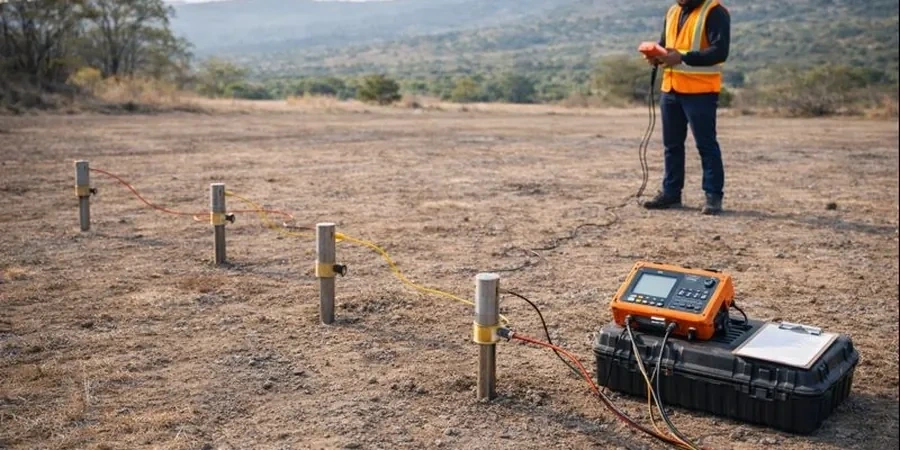
Vertical Electrical Sounding (VES)
A four-electrode Schlumberger or Wenner sounding that measures apparent resistivity at increasing depth increments at a single location. Ideal for mapping the thickness of river terrace gravels, depth to Lias Clay, or bedrock profiling beneath a proposed pad foundation. We typically run three to five soundings across a site and invert each to a 1D layered model, validated against at least one borehole or trial pit.
2D Electrical Resistivity Tomography (ERT)
A multi-electrode profile that builds a continuous cross-section of true resistivity. Best suited for detecting buried channels, variable fill thickness, karst-like dissolution features in the Northampton Sand, or the lateral extent of low-resistivity clay seams. We supply processed pseudosections and inverted resistivity sections in formats compatible with CAD and GIS platforms.
Typical parameters
Top questions
How much does a resistivity survey cost for a typical Northampton site?
For most residential or light commercial plots in the Northampton area, electrical resistivity surveys range from £560 to £780. The final figure depends on line length, number of soundings, and how much preparation is needed to clear electrode contact points. We provide a fixed quote after reviewing the site plan and any existing ground investigation data.
What depth can VES and ERT reach in the Nene valley geology?
With a standard 80-metre Schlumberger spread, VES can resolve layers down to about 20–25 metres. 2D ERT using 72 or 84 electrodes with 5-metre spacing typically images 12–15 metres with good resolution. Deeper targets—such as mapping the Lias Clay basement beneath thick gravel—may require extended arrays reaching 50–60 metres, though resolution decreases with depth.
Can resistivity tell the difference between saturated sand and clay?
It can, but the interpretation needs care. Saturated sand in Northampton typically measures 40–70 Ωm, while Lias Clay sits below 25 Ωm. There is a gap, but silty clay or clayey sand can blur the boundary. We calibrate every resistivity line against at least one physical investigation point—a trial pit or window sample borehole—so the geoelectric boundaries match the actual lithology.
How long does a resistivity survey take on site?
A single VES sounding takes about 45 minutes including setup. A 2D ERT line of 72 electrodes typically requires two to three hours of field time, plus another half-hour for layout and contact testing. For a standard Northampton residential plot, we usually complete all fieldwork in one day and deliver the processed sections within three working days.